Maps from Past to Present
Maps from Past to Present
Maps have been geographical tools used by humans for thousands of years to understand, interpret, and navigate the world they live in. Throughout different periods of history, maps have undergone various stages of development and evolution. The importance of map usage increased with geographical discoveries, leading to their proliferation and widespread use. These explorations also influenced the content of maps, resulting in the creation of extensive and detailed maps.
Today, maps have become easily accessible through digitalization and have become a part of everyday practicalities for everyone's travels.
There are multiple types of maps, with political maps being the most commonly used. Political maps can be defined as maps that delineate the boundaries of countries, regions, and local administrative units. For more information on political maps and world political maps, you can refer to the continuation of the content.
When Did Maps Emerge?
Mapmaking has been a pursuit that has spanned thousands of years. Although the exact date of the emergence of maps is not known, traces of maps can be found dating back to cave paintings. These early maps were different from contemporary maps, being smaller in scale and less detailed.
Today, maps are drawn on specific scales. As technology advances, these scales and drawing techniques improve, becoming more error-free. For example, the advancement of satellite technology has made it possible to create highly accurate maps by providing a view of the Earth from space. Mapmaking is known as "cartography."
While map types did not distinguish themselves in the past, they are sharply defined today, closely related to the development of maps and cartography. Advanced map types have been categorized in the modern era. However, it is possible to say that the most widely used map format since ancient times has been political maps. Old maps that featured the boundaries of countries and natural geographical features are among the earliest examples of political maps.
Oldest Examples of Maps
There is ample evidence to suggest that the history of maps dates back to ancient times. However, the oldest known examples of maps exhibit impressive features considering the era in which they emerged. So, when did the oldest maps come into existence, and what are some examples? Here's the answer:
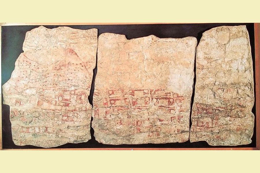
Çatalhöyük City Plan
The Çatalhöyük City Plan is the oldest known map in the world. This map depicts the layout of the settlement and can be considered both the world's first map and the first political map. It outlines the administrative boundaries of Çatalhöyük and is dated to around 6200 BC. Today, it can be seen at the Museum of Anatolian Civilizations.
Babylonian World Map
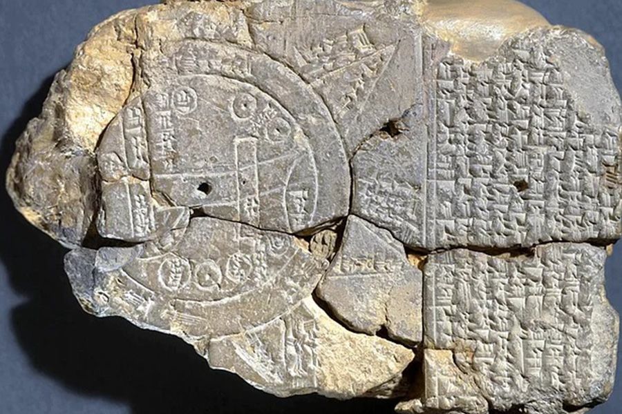
The Babylonian World Map is one of the oldest known maps. It is estimated to have been created around 600 BC. This map depicts the world as a flat disc surrounded by "water." It is quite small in size, and many places outside Babylon are noted as "unknown lands." In this sense, the map can be regarded as a political map of the world because it defines the administrative boundaries of Babylon.
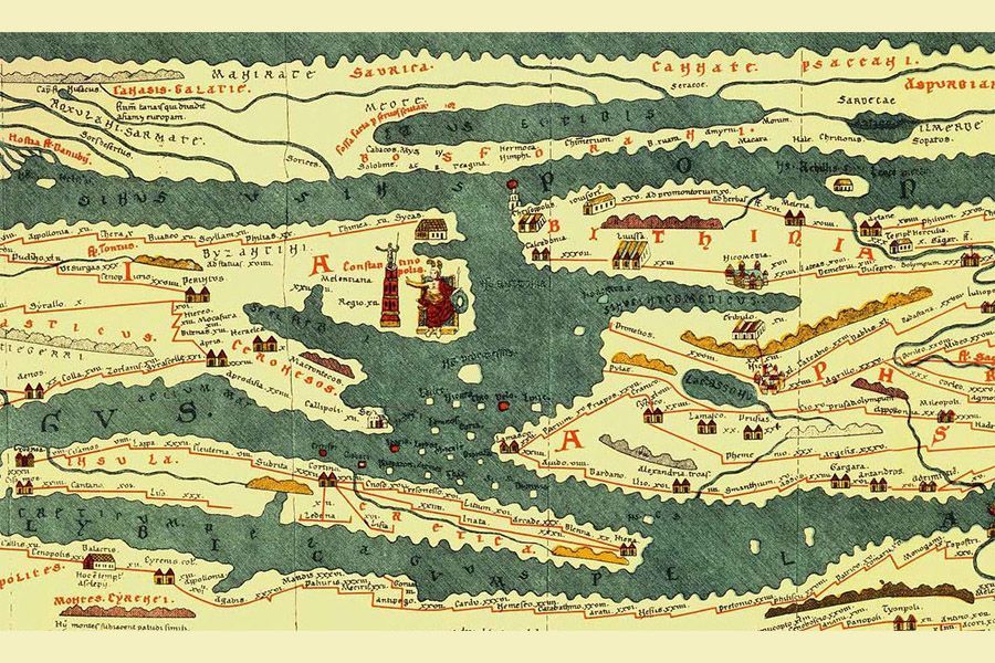
Ptolemy's Map
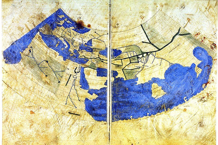
The Greek scholar and geographer known as Ptolemy is famous for his work on geography in ancient times. He wrote the world's first geography book and created a remarkable map using mathematics and geometry. Even today, the size of Ptolemy's map is quite impressive. It includes oceans and continents.
Tabula Peutingeriana
This map is a guide prepared for the roads built by the Roman Empire. It serves a significant function and stretches from Europe to East Asia. All roads on the map lead to Rome, and it details the road networks and systems of Rome. It measures 7 meters in length, making it quite attention-grabbing.
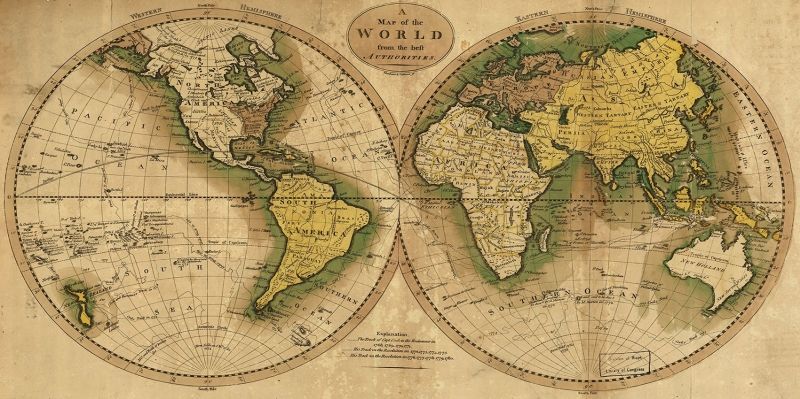
Waldseemüller Map
Waldseemüller was a German cartographer who included the American continent in his map created in the early 1500s. While this feature makes the map quite significant, it is not widely known. (2)
While there are many examples of historical maps, it can be said that some of the most important examples are the ones mentioned above.
Types of Maps
Today, there are multiple types of maps available, catering to various fields of study and purposes. So, what types of maps are used in today's world?
- Topographic Maps
- Isohip Maps
- Geographic Maps
- Aeronautical Charts
- Political Maps
- Physical Maps
- Atlas Maps
- City Maps
- Tourist Maps
- Nautical Charts
- Geological Maps
- Wall Maps
- Morphology Maps
These categories can be expanded and customized. In this content, we will provide detailed information about political maps.
What Is a Political Map?
Political Maps: A Reference to the World
Political maps, also known as reference maps, are like other maps – they serve as a reflection and reference to our world. What sets political maps apart from other map types is their specific focus on delineating boundaries. A political map of a country showcases the administrative boundaries of regions and cities within that country. A world political map, on the other hand, displays the political boundaries of continents and countries.
Political maps do not include geographical features extensively. However, some major rivers, rivers, and, of course, oceans may appear on these maps. For example, even on a world political map, you will find oceans and seas. In some cases, these geographical features naturally define the boundaries of countries and regions, making their presence on political maps quite logical.
Political maps help people better comprehend the geography of the world. In schools and educational institutions, political maps are among the first map types students encounter, and they are the most widely used map types worldwide. Due to their straightforward nature, political maps are easy to read and do not require extensive knowledge to understand.
Political maps are used both in print and in digital formats. Often, when users search for "Turkey Map," "Europe Map," or "World Map" on the internet, the results they find are in the form of political maps.
Political maps can be created for all administrative units. A world political map delineates continental and country boundaries. Political maps of countries include the boundaries of regions and cities. Political maps of cities outline the boundaries of districts and local units. Similarly, political maps can be created for districts, and these maps display the boundaries of streets, neighborhoods, and other small administrative units.
Difference Between Political Maps and Physical Maps
Political maps and physical maps are often confused, but there are significant differences between them. Political maps depict the boundaries of continents, countries, and regions and may include some geographical information. It is normal for political maps to feature boundaries or significant geographical structures. For example, the Black Sea, which forms a natural border between Turkey and Russia, appears on political maps.
On the other hand, physical maps do not include any political boundaries. Physical maps are created based solely on natural geographical features found on Earth. These maps display the planet's natural features, such as mountains, lakes, seas, and rivers. Understanding national borders by looking at physical maps can be quite challenging for someone without specific training. (4)
Physical maps are crucial for learning and understanding topographical features. Here, topography refers to the geographical structure of the Earth's surface. These maps represent various natural features, like high and low areas, mountainous regions, based on the Earth's natural geography, and often use different colors to differentiate them.
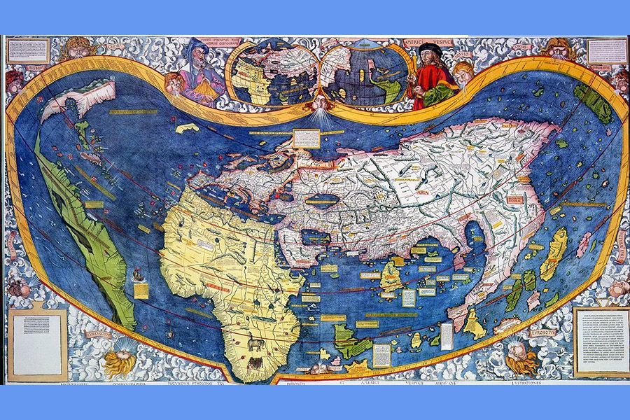
Piri Reis's World Map
Undoubtedly, the most renowned cartographer and mariner in Turkey is Piri Reis. Piri Reis is a significant figure, known for his world map created around the year 1510. He was a famous and accomplished mariner who served as the Chief Admiral (Commander of the Navy) for the Ottoman Empire for many years.
In his work titled "Kitâb-ı Bahriyye," Piri Reis included this world map and initially presented his work to the reigning Ottoman Sultan of the time, Suleiman the Magnificent. Piri Reis's world map is famous for its remarkable accuracy for its era. Particularly, the boundaries of continents are depicted in great detail, and its level of precision is highly noteworthy.
Maps allow us to comprehend and make sense of the world around us. Understanding our planet, grasping national and international boundaries to which we belong is crucial. Map reading is a skill that every individual should possess. Especially, since political maps are easy to read, can be readily created, and are easily understood, starting map education with political maps is a wise choice.
Maps have played a significant role in the development of the world. The transfer of knowledge and culture is closely related to geographical mobility. Therefore, having knowledge about maps is of great importance.
Sources:
https://www.britannica.com (1)